

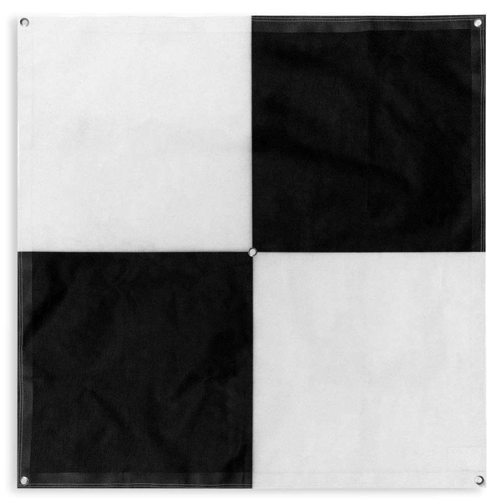
Sky High Bull's-Eye (24"x24") Drone Ground Control Point GCP - UAV Aerial Target for Mapping & Surveying (6 Pack) | Center Passthrough (Black/White Markers) | Pix4D & DroneDeploy Compatible
Product details
| Management number | 211311033 | Release Date | 2026/04/04 | List Price | $24.00 | Model Number | 211311033 | ||
|---|---|---|---|---|---|---|---|---|---|
| Category | |||||||||
- 24”x24” AERIAL TARGETS - Designed for low to medium altitude drone mapping and scanning, these drone GCPs were made for drone mapping up to 400 feet. The standard size is useful when scaling and verifying the map, providing a standard reference distance during post-processing.
- DRONE GCP WITH CENTER PASSTHROUGH - The center passthrough design allows pre-established survey stakes or survey markers to be slid directly through the GCP for added convenience when mapping. Using the passthrough, a surveyor can place markers days or weeks prior to the flight mission. The GCP can then be placed over the existing markers with precision as the surveying marker remains in place during the placement and retrieval of the aerial targets.
- LIGHTWEIGHT & DURABLE AERIAL TARGETS - Using a weatherproof mesh material, these GCPs were made to be highly visible yet lightweight, a big benefit when traveling or placing the GCPs in the field. The material is made with a matte finish which reduces glare from sunlight and overexposure on sunny days, which makes selecting the center of the target easier during post-processing.
- GCP WITH SOFTWARE COMPATIBILITY - These GCPs are compatible with many popular photogrammetry reconstruction software from the leading companies in the space drone mapping, photogrammetry, and surveying space,. The GCPs are compatible with most auto-detection software, and these GCPs have been used in a wide range of industries and educational training programs with great success.
- UAV GCP WITH CORNER ANCHOR POINTS - With eyelets at each corner to easily anchor the aerial targets, the corner anchor points prevent the GCPs from moving during mapping. The anchors also allow the GCPs to be left in the field if needed for repeat flights over a period of time, providing peace of mind that the GCPs offer repeatable location data for high-accuracy mapping and photogrammetry.
| Item Weight | 1.85 pounds |
|---|---|
| Item model number | GCP001 |
| Package Dimensions | 12 x 12 x 1.25 inches |
| Is Discontinued By Manufacturer | No |


Bestseller ranking
Unmanned Aerial Vehicles (UAVs)


Correction of product information
If you notice any omissions or errors in the product information on this page, please use the correction request form below.
Correction Request Form